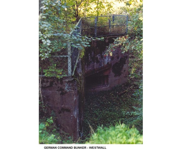
 German Command Bunker - West Wall;
Credit: David Heal
Chronicle.lu has teamed up with local author and tour guide David Heal of Luxembourg Battles for a historical series marking the 80th anniversary of the Battle of the Bulge.
Over the coming weeks, this series will look at how various villages and towns were involved and where one can go to see what happened.
Next up is Reisdorf. According to David, this is a little-known area, "which is a shame", especially for those looking for remains of World War Two.
To get there, take the road from Echternach along the Sûre to Diekirch or alternatively, the road along the Sure from Diekirch to Echternach.
At Reisdorf, beside the bridge over the Sûre, there is a building with a car park, which was the railway stations - the railway ran in this stretch, from Diekirch to Echternach and then on down to Grevenmacher. This is now the Tourist Office. When open, the Tourist Office has a brochure and sketch map showing the Battle of the Bulge walk (but David advises against trying to do it all, as it is over 30 kilometres). The brochure is also available at the National Museum of Military History (MNHM) in Diekirch. The walk is marked on the ground by Blue Stars and arrows, but, to avoid any confusion, David advises using them as markers rather than indicators.
Cross the bridge and immediately turn right. The road here is rather rough after a while but press on. At the end of the houses, there is a "rather strange" house. David noted it was built as offices and a small factory for a gypsum mine. Carry on and cross the bridge into Germany. Immediately in front, there is a slit in the wall. This is the forward part of the West Wall and was a machine gun post. The entrance was in what is now a garden.
Turn right, and then left, to arrive at a roundabout. Take a right fork here and go to the top of the hill, passing a small German war cemetery on the way, and also a set of stations of the cross which lead to a chapel at the top of the hill. At the top, there is a bunker. This is known locally as a Hitler bunker, but experts will know this is a misnomer - Hitler bunkers were field headquarters for Adolf Hitler. This is just a bunker he visited before the war or just after the start, clarified David. It housed an artillery piece. Along with most of these bunkers, after the war a pile of dynamite was put inside and set off, lifting the roof up and blowing out a part of the walls - see the line where the concrete snapped.
Go downhill for a little while and there is a track entrance. David suggests parking here but advised caution as this is a well-used road. Walk along the track and one will come to the entrance to an ammunition magazine. This supplied ammunition to the bunker at the top. In fact, the whole of the hillside here has these magazines. One cannot go in as it is now sealed as a bat sanctuary, and in any case it is just a T shape.
Come back to the roundabout and turn right. After about 100 metres, turn left on to a "not very good" road. Drive to the edge of the fields, and park there. On the left, there is a signpost explaining about the bunker that is here. It was a command bunker. "Why you would put the command bunker in front of the front line is a mystery to me," said David. Down a few steps one will find the bunker and can go in if it is not flooded. Then back to the roundabout and the Reisdorf bridge.
Now carry straight on towards Diekirch and then take the first road at the end of the village, signposted as Hoesdorf. Follow it up to the top of the hill, and at a cross fork left.
Carry on until arriving at the start of the forest and stop. This is the first stop. It was a company HQ from September until 15 December 1944. The GIs were bored so they carved names, etc. on the trees, noted David, adding that most of them have survived. There was a "really impressive" set of carvings on a tree that was knocked down in the storm of 1999 and destroyed by the foresters.
On along this track, and fork right. Just before the end of the forest on the right, there is a reconstructed dug out which was for a battlefield mortar, and also acted as a guide for the jeeps bringing hot food up to the men on the front line.
On again and turn right. There is a sign saying that there are tank tracks still there, but David noted they have now pretty much disappeared (foresters). On again, and there is a track to the left marked by a signpost giving the story of what happened here.
Park and walk up and into the forest. To the right, there is another signpost showing the details of the machine gun which was once nearby. There is a small track into the edge of the forest and after a few metres a pit. This is where the machine gun was situated. It covered the field in front. On 15 December 1944, the Germans crossed the Sûre (some in rubber boats, but some had to wade) and climbed the hill. They came to the edge of the forest to one's left. The first, second and third waves of men charged across the field and were wiped out by fire from this machine gun and by another in a lost position in the cops to the right. The field mortars also joined in and by the time the third wave charged larger mortars in Bettendorf had joined. Carry on along the edge of the forest here, although there is no patch, and one will find foxholes used by the US army. They turn to the left and continue for as long as one wants to walk and climb over fallen trees.
After a little while, one will see a white painted house on the other side of the river. The story is told - and appears to be true, according to David - that a US patrol crossed the river one night, walked around a corner of this house and ran into a German patrol going in the opposite direction. They exchanged cigarettes and chewing gum and went on their way. This came to light in 1984. The patrol members had been afraid to say anything before as "some clever person" would have demanded to know why they had not fought it out - "a complete massacre for both sides", noted David.
Having seen enough foxholes, turn left and head to the path which leads through the forest. Turn left on the path and it will bring visitors back to the beginning.
There are no contemporary photographs of this area, virtually the only area where this can be said. "Why no photographers ever got here is a mystery," said David.
In the event, while the fighting on the plateau here was a tactical victory, the Americans had to pull back as the Germans penetrated along the Sûre valley towards Diekirch and they would have been cut off.
David suggested allowing a couple of hours for this trip.


