 Credit: MLogat
Luxembourg's Ministry of Housing and Spatial Planning, together with the Ministry of Labour, the Environmental Administration, the Water Management Administration and the Nature and Forestry Administration have announced that the Housing Observatory (Observatoire de l'habitat) has published a report on the outcome of a study that focuses on the use of land in Luxembourg for construction over the period 2004-2022 and offers a perspective on the long-term trends in urban and residential development in the country.
This not only makes it possible to measure the impact of economic and demographic developments on the use of land resources, but also provides essential indications for future urban planning.
The study examined the two main types of construction: "newly built", and those previously built, "rebuilt". It compared the dynamics of the extension of urban areas with the process of increased density of the existing urban fabric, thus assessing the concordance between past trends and the objectives related to land use planning.
The analyses carried out drew the following conclusions:
During the period 2004-2022, construction began on 2,202 hectares nett, representing an average of 122 hectares nett per year. Over the same period, reconstruction took place on 713 hectares nett, or an average of almost 40 hectares per year. Taken as a whole, 2,915 hectares were used for new construction or reconstruction.
Between 2004 and 2022, more than 73,000 new housing units were developed in the country, with a majority coming from new construction. Approximately 50,000 units were newly constructed and 23,000 units came from the reconstruction of existing buildings. Of these 73,000 housing units, 9,000 were still under construction in 2022.
34% of new housing built or rebuilt between 2004 and 2022 are located in the municipalities of the Luxembourg City region, 22% in the municipalities of the South and 30% in the remaining municipalities. The municipalities of the Nordstad only represented 3% of new housing over this period. These proportions are close to the relative importance of these types of municipalities in terms of inhabitants. The highest net residential density was observed in the South region, with 64 dwellings per hectare on newly built areas and 77.5 dwellings per hectare on rebuilt areas – values slightly higher than in the Luxembourg City region.
According to the Ministry, the long-term trends in urban and residential development in Luxembourg between 2004 and 2022 demonstrate the importance of implementing the Master Programme for Spatial Planning adopted by the government in June 2023. The aim of this programme is to improve the quality of life through the coherent, structured and sustainable development of the country. As part of this implementation, the Ministry advised that it is essential to open a frank and constructive dialogue with sectoral policies and municipalities in order to place the overall cohesion of the territory more centrally in local strategies.
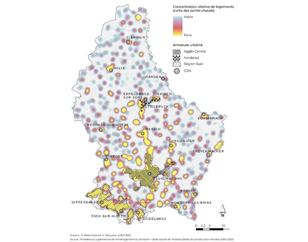
The map shows the spatial distribution of new housing, ignoring the administrative boundaries of the municipalities. It shows both a high concentration of new housing in the three urban areas and the Development and Attraction Centres (CDA) and a dispersion of new housing throughout the rest of the territory. This dispersion, and the low level of density that accompanies it, complicates the provision of mobility infrastructure and increases the cost of construction and operation, ultimately leading to increasing living costs for people living in these areas.


