 Credit: DATer
Today marks the entry into force of Luxembourg's four sectorial plans aimed at improving the quality of life of residents and strengthening environmental protection.
On Friday 26 February 2021, Luxembourg's Minister for Spatial Planning, Claude Turmes, presented the sectorial plans related to housing, landscapes, transport and economic activity zones. These plans, which enter into force on Monday 1 March 2021, are designed to frame territorial development in a sustainable way at the national level. They correspond to the four main fields of action of spatial planning, namely urban and rural development, the economy, transport and the environment and natural resources.
Minister Claude Turmes explained: "With their entry into force [...], a historic step has been taken in the policy of spatial planning: it provides the state with the necessary instruments for the long-term strengthening and the putting into practice of the essential elements for sustainable, coherent and responsible land use planning". He added that the objective of the plans is to "promote development of the national territory which protects the landscapes, enhances the common resources of a region and contributes to efficient use and rational needs in terms of land use”.
The main objective of these sectorial plans is thus to reserve land for the future realisation of projects in order to anticipate future needs and to avoid development contrary to the objectives of spatial planning. While ensuring the protection of certain spaces, land will be reserved to meet demand in terms of housing, transport infrastructure, business areas and the protection of Luxembourg's landscapes. For each plan, an interministerial monitoring committee has been set up to "monitor[...] the reality on the ground".
Since the initiative launched in 2004, the four sectorial plans have been the subject of a public consultation process with residents, municipalities and socio-economic players in Luxembourg. There has also been sustained consultation at the technical and political level.
Minister Claude Turmes added that the plans would enable the government to "guarantee a territorial development of the whole country which is at the same time coordinated and coherent, framed and sustainable".
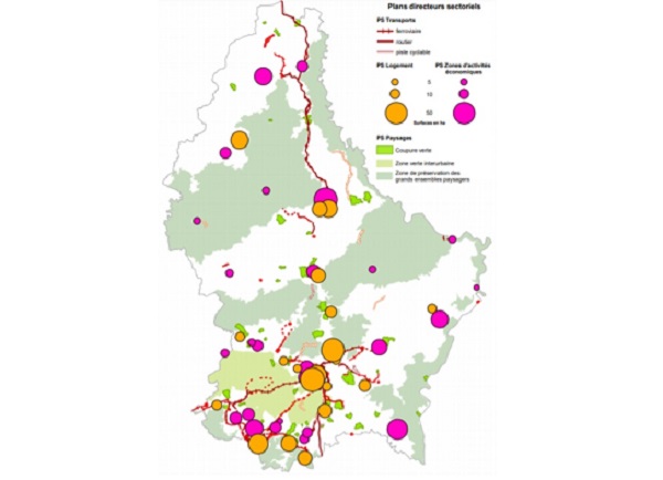
Housing sector plan: the objective of this sectorial plan is to define priority housing zones intended for the creation of housing by reserving surfaces and to contribute to a distribution of the population in the most appropriate places of the national territory. The plan also aims to promote the creation of affordable housing, to which 30% of the gross building area will be dedicated.
Economic activity zones plan: this sectorial plan aims to reserve areas dedicated to the development of primarily craft and industrial activities to support national economic development. It is also a question of counterbalancing an uncontrolled development of the territory as well as the additional sprawl of the landscape and of encouraging the municipalities to develop and to implement inter-municipal strategies for the priority implementation of regional economic activity zones. In the coming weeks, a guide on the implementation of this sectorial plan (according to the principles of the circular economy) will be published and made available.
Transport sector plan: the objective of this sectorial plan is to facilitate the transposition of the global strategy for sustainable mobility by reserving areas and corridors to be kept free of any construction intended to accommodate transport infrastructure projects.
Landscapes sectoral plan: the objective of this sectorial plan is to protect landscapes by preserving certain spaces from additional fragmentation and sprawl and by keeping spaces under urban pressure between localities free from construction. In this way, landscapes can continue to fulfill their landscape functions (namely ecological, recreationional, agricultural and forestry production and tourism functions, etc.).
The parts of the national territory covered by a superimposed zone resulting from these sectorial plans are illustrated using maps. Everyone can thus determine whether or not a piece of land is affected by the prescriptions of these plans. The maps can be consulted on the websites of the Department of Spatial Planning (www.dater.lu) and the National Geoportal of the Grand Duchy of Luxembourg (www.geoportail.lu). The graphic part of the sectorial plans indicates the parts of the national territory covered by a superimposed zone resulting from these plans, which is defined at a scale of 1:2,500 on the basis of the digital cadastral plan as issued by the Land Registry and Topography Administration (Administration du cadastre et de la topographie).


